Would you like to make this site your homepage? It's fast and easy...
Yes, Please make this my home page!
Patrick Kerrin's 2001 Chase Page -
05-29-2001
Just scroll down!
An interesting day that ran the gammit of seeing a lot of old
friends in the field, to a storm that initially disappointed -
then made me think I was going to see a big tornado, to hordes
beyond belief (the label "Insane Clown Posse" comes to mind to
describe the whole damn mess, but a rap/metal band already has
that name - very poor behavior was observed on the part of some
chasers), to the worst mosquito attack I've experienced since
I was a kid, to allowing these distractions to contribute to
poor use of "The Roads of Texas" road atlas and not making
the right road choices that might have kept me ahead of the
storm though Turkey and Childress, TX (I was stuck S and W of
the storm by that point), to having my brake warning light come
on late in the chase.
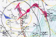
05-29-2001 - SW Upper flow in advance of short-wave trough
with decent speed max up stream at mid and ut levels.
Excellent shear profile expected by afternoon with high CAPE
suggested favorable scenario for tornadic supercells.
Saw Steve Hodanish (PUB NWS FO) and Charles Redwine, et al,
at the AMA FO and the consensus was from AMA to W Of LBB.
I had centered a target region around Littlefield, TX (Waylon
Jennings' home town!) and followed my tracks from 28 May
through Canyon down to Hereford. Spoke to Lon Curtis and
he saw no flaws with my reasoning (and kept me informed with
frequent sfc obs and radar updates through out the day
early evening - thanks Lon!). Al Moller was targeting
Plainfield.
Heading down US 385 I noted TCU were forming in a narrow
NE-SW convergent zone. I pulled into the Springlake and saw
Bill Tabor and Gene Moore. As we chatted and looked at some
data the first cb *exploded* directly overhead. We moved a
few miles south through light anvil rain and stopped to
observe. Soon other chasers began to appear and the rest
of the day would be crowded! We could see the SW end of the
convergent zone at the dryline (~ 15 miles WSW). The region
from N through the NE was scattered with young storms jostling
for dominance. We moved E through eastern Lamb county and
stopped to say hi to Bobby Prentice, RJ Evans, Scott Fitzgerald,
and George Kourounis. Gene shared some insights with me that
prompting him to consider bailing on this storm in favor of a
better looking cell to the N between us and Amarillo (our storm
was weak and relatively disorganized with a too-tilted-over updraft).
Gene decided a few minutes later to make the move N and we
wished each other luck (thanks for the insights Gene and
for pointing out the N option) - I decided to stay with my forecast
and move E on US 70.
I soon stopped to discuss the situation with the Doswells,
Brian Curran (who had arrived moments before me), and John
Monteverdi. We moved N and E and stopped to take some images
like the next one below.
|
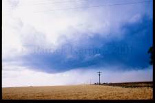
05-29-2001 - NE Hale (NW of Edmonson, TX) county weakly rotating
lowering. John Monteverdi's hand held (i.e.
it did not need to be big and on the roof of chase vehicle
to work) weather station registered a Td of 60.4 - much to
our chagrin. My 16z sfc analysis suggested Td's of 64-65 to
NW and N of Lubbock. I can only guess that the convection near
Canyon AOA 17z may have processed some of the moisture to
it's south (but then one would have to ask why the cell
that fared so well south of AMA - did so in an area which was much
closer to the region that experienced the early afternoon
convection - I dunno)! Please note I needed to adjust the
contrast/brightness digitally of this image to match the scene
in the sky (I had slightly under exposed).
|
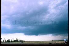
05-29-2001 - Same location as above. Note John
Monteverdi in lower right corner and broader meso on a
later cycle. I expressed some hope for the future at that point!
Again, the time for all these images will be identified from my
video when I can access the audio portion. I will attempt to
get the exact times for the images in the sequence so as to best
correlate the with the radar images shown below (thanks to Lon
Curtis for saving these while nowcasting from home). I have
correlated into this sequence based on the general position
of the cells in the radar images.
|
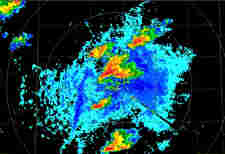
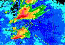
05-29-2001 - Here is the storm we were on - as shown in
Amarillo's 2213z reflectivity image. Note the weak signature
in SW Swisher County (the bottom-most cell in this image). Also
note the cell NW of AMA that evolved to produce the long lived
White Deer, TX tornado as well as the cell SW of AMA (which I
believe Gene Moore later described as spectacular).
|

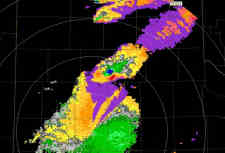
05-29-2001 - This is the 2238z AMA reflectivity image, highlighting
the movement to the east of the Supercells to the NW and SW of AMA.
|
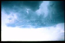
05-29-2001 - Our group headed E to I-35 with Brian and I taking the
Interstate north and the E on FR 145 through Kress, where a
huge number of chasers had assembled. Many University and
Chase Tour vans and the OU DOWs (which very likely had a
good proportion of the crowd following as uninvited tag
alongs). At this point, defensive driving has to become
a priority as there are many making unthoughtful moves (conscious
and unconscious!) on or about the road surface. Ran into my friend Bruce Haynie somewhere E of
Kress (along with my first meeting with TAMU's Jason Jordan
and some other responsible chasers that Bruce and Jason knew -
but I unfortunately did not get all the names straight with all
the extraneous activity). Good to meet y'all nonetheless.
This and the following two images were taken along
FR 145 between the intersection of FR 400/145 and FR
375/145. this is were I was seriously attacked by mosquitos
- so bad that blood was trickling from some of the bites and
Bruce Haynie and Brian Curran were repeatedly killing these
little @*&#s on my back and shoulders. I know now why
Texans wear boots and long pants (especially in heavily
irrigated regions) - and this could have been much worse
(e.g. Fire Ants). The storm cycled though a few mesos
and these next two images represent some of the associated
updraft regions.
|
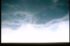
05-29-2001 - Both this and the previous shot show some
erosion around the updraft - but none of the cycles showed any
significant RFD. This was also a period to watch out for chase
tourists and/or University Chase Team members running across the
road ahead of you while they were looking at the sky and not
the road/traffic!
|

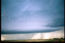
05-29-2001 - One of the cycle pairs produced this pseudo
combination shelf/inflow tail.
|

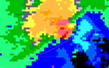
05-29-2001 - This Lubbock Storm Relative Velocity image (2319z)
showing marked rotation in far SE Swisher County matches up
spatially with the images shown below!
|
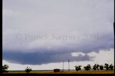
05-29-2001 - As I approached the FR 145 & FR 385
intersection the next meso in the cycle took on a vastly
different appearance. I pulled south on 385 about a mile
to avoid most of the crowds and watched/photographed/videoed
the evolution of the best meso of the day so far. This
formed rapidly to the WSW of the previous meso and exhibit a much
lower LCL/CCL. the associated inflow from the ENE persisted along
with the good rotation. I thought this was going to become
tornadic, and Lon called to say how impressive the signature
appeared on radar (see above!).
|
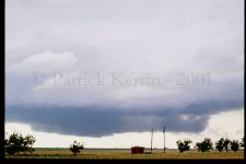
05-29-2001 - Here is another view from the same
location of the same sequence. Please note I needed to
adjust the contrast/brightness digitally of this and the
previous image to get them to match the scene in the
sky (I had slightly under exposed).
|
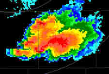
05-29-2001 - This 2343z AMA reflectivity image matches up with
(or maybe just a little later than) the two images below (one of
which is a zoomed view of the other). The reflectivity morphology
became more HP-ish with area of interest on/just E of the
Swisher/Briscoe County lines.
|
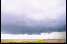
05-29-2001 - This image was taken a mile or so south of the FR
145 and FR 378 junction in extreme SW Briscoe county - looking
north up FR 378. Note probable gustnado to the left of the
telephone pole. A zoomed image appears below. Again, this and
the following image required adjustment with the
contrast/brightness to match the scene in the sky (slightly under
exposed).
|
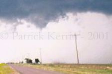
05-29-2001 - In this contrast/brightness adjusted zoomed
view of the above image one can better see the probable
gustnado (dust whirl at the surface between the first two
telephone poles). The cloud base weakly cone shaped/scuddy
lowering is displaced to left (over the telephone pole). Again,
most probably a gustnadic situation!
|
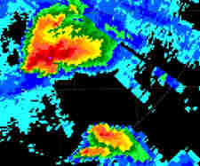
05-29-2001 - This and the next AMA image is from 0034z. In this
reflectivity image one can note the cell has moved east into
central Briscoe County and may correlate to the morphology AOA the
time of the apparent Silverton tornado (as reported by Gilbert
Sebenste). Unfortunately, after taking the taking the above photos I
chatted with some of the chasers I had seen earlier in the day and I
did not turn page 29 of "The Roads of Texas" to page 24 where I
would have seen easy east road options that would have allowed
me to stay closer to the storm (or at least S/SE). We decided
to give the long S then E option a try and it put us well SSW
of the storm. I then started to get my brake warning light come
on (what a day!) and pulled back - here comes the drop off the
Caprock and do I have brakes that will work?? I tested things
to the point where I felt it was safe to proceed and that was
the end of the chase (FR 97 to 70). I did note how damn red and
full of red dust the sky was to my east as I crossed into Hall
County on 70, just south of Turkey, TX (with the storm now off to
the E of Turkey)!
|

05-29-2001 - KAMA SR vel image from 0034z (same as
above). Another nice couplet!
|
Seems like almost every chaser out that day converged on the Kettle
Restaurant in Childress, TX. I pulled in just after Chuck and
Vicky, and I believe Al Moller had just pulled in and we couldn't
get a table as the place was full of chasers! We bailed and went
to the McDonald's across the street and it was packed with chasers
too (lots of University Teams there). I pulled off as I was now
concerned as to finding a place to sleep. Once that was
accomplished, it was back to the Kettle for the 'second seating'.
I had a fun dinner with
Tim Marshall and Carson Eads (Tim was showing highlights of
the 30 minute White Deer tornado he had just shot a few hours
earlier on on his very fine Sony 3 CCD
Digital cam). If I recall correctly this was still chaser central
with William Reid and the Tempest Tours people at the next booth
and Dr. Howie Bluestien at the one after that (Rich Thompson/Roger
Edwards et. al. one row over from them, and others all
over the the room). As I pulled back into the hotel and stopped
I heard a definite squeak from my brakes. That meant it was going
to be an early morning scramble to deal with the situation (see
the 30 May Chase account for the details of how that progressed)!
