|
|
|
Just scroll down!
This is one of the most memorable chase day's I've ever had, and I ended up seeing some of the most amazing structure I have ever seen.
Started the day with a trip out to the Amarillo National Weather Service Forecast Office (many thanks to Meteorologist in Charge Jose Garcia who welcomed me for the first of three consecutive morning visits). Amazing to see that AMA NWS FO almost devoid of chasers... one day I too will have a laptop, the tool that allows the chaser to be fully independent! I chatted briefly with Chuck and Vicky Doswell and a father and son chase team from Oregon.
With sfc and mandatory maps in hand it was back to the motel where I joined John Moore and his daughter Beth to check out some model guidance (along with phone discussions with Al Moller and Lon Curtis). Along with John's and Beth's chase partner Jim Williams (Los Angeles, CA) the caravan included Greg Breneman (Chandler, AZ) and Linda Kitchen and Kathy Velasquez (AZ). Matt Crowther and Betsy Abrams (Weather Channel - Atlanta) soon arrived and we all left to head N to play the boundary in SW Kansas (we briefly saw Dave Gold/Silver Lining Tours at the Gas station before leaving AMA). I am not as inclined to caravan as I was in past, but wanted to today as I was going to into a data void (as everything library-wise would be closed on a Sunday) and many of these folks are old friends!
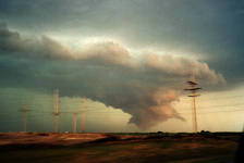
What followed became a 'Tale of Two Chases'; the first with the caravan that saw the storms up in KS (a pair of 35mm SLR shots from Jim Williams are included below - some of my video images of this portion of the chase will follow when I get access to a vidcap tool), and the second portion of the chase on my own in NW OK.

05-27-2001 - 35mm image copyright Jim Williams. This beautiful 35mm image taken by Jim captures the outflowish nature of the formation. It still prompted over 150 calls to the Dodge City National Weather Service Forecast Office (which is between our location and the cloud lowering in the image) who were astute enough to keep things limited to a Severe Thunderstorm Warning (although someone apparently went ahead and blew the sirens in Dodge City). Kudos DDC NWSFO! Thanks to Jim Williams for allowing me to include the images he took while we were sharing this experience! Do check out his excellent 'Dryliner' website! |
I continued to SE of Dodge with the best cloud base rotation of the day evolving to our north. Of course 'Murphy's Law' came into play as I had inadvertently touched the 'Special Effects' button on the camcorder as I made an adjustment while mounted on the dashboard. Ergo, the part of the chase with the best cloud based action is captured in 'Mosaic'. You can guess the nature of my comments when I got to our next stop and took the camera off the dash to film and noticed the error. Why in tarnation they put this crap on video cameras I don't know! I continued SE of DDC with John, Beth, Jim, et al.
While the caravan began to encounter other chasers and happily exchange stories, I began to become concerned about my fuel situation (I was now on 1/3rd of a tank and began to realize how far I was from a urban area - I really had it laid out for me as the caravan pulled into a town and the power went off just as I saw the gas station!)! As we headed W on US 160 from Ashland it was evident that the nature of the convection was changing. I really want to thank John Moore for patiently giving me all my potential road options over the 2m - thus allowing me to keep moving with my eyes on the road. I am now sure that if I had to stop and study my options I would have been 'eaten' by the impending derecho and missed the structure you'll see below!
I decided on the south option down US 283, and noticing the evolution of the convection suggested that John et al do the same for meteorological reasons! They did and we stopped one last time together just inside the OK border - the shelf structure was beginning to get much more organized and was awesome (I think I shot some video)!
I chose Laverne, Ok as a target to get gas (as I had in '92 & '94 and hoped there were still stations in town) bid my friends farewell and got down to US 64 and E a few miles to head south again on US 283. As soon as I stated down 283 I began to notice I was not pulling ahead of the monster on my tail. Something hit my windshield hard from above - it was dark and made the glass shudder (probably a wind swept bird). I pushed hard to get to Laverne - the key was to get there while there was still power (if there was any to begin with!) but this derecho was still right on my tail (the speed limit in Oklahoma is 70 m.p.h. and that's all I'll say - this was now a safety issue).
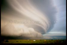
So I get to Laverne and saw a station on the right with power on and an open fueling slot. It had old style 'analog' pumps that were FAST and I put $20 worth in with a perfect pump! I made the quick payment and made some quick comments about the impending derecho (now entering the town). I stuck with the speed limit in town as the storm started to envelope me, but floored it as soon as I hit the open road. I had never seen a storm move so fast. Over a period of about ten minutes I put enough distance between myself and the storm to start to gain some perspective. I had the 'Mother of all Haboobs' (to quote another chaser's assessment) to my west and a HP stack of plates to my east! I never got around to photographing the haboob (I *may* have some video - I certainly have the memories!), but I did get the derecho depicted below.

Same time and location as above. This and the previous image were metering OK to handhold the shot, if I recall correctly. |

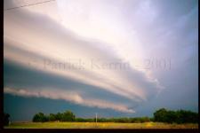
Same sequence/location/time as the previous shot. |

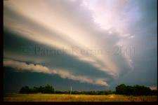
Same sequence/location/time as the previous shots. These shots were taken in fairly rapid succession and it is interesting to not how quickly the structure was making subtle changes! |
There are other slides I took in this sequence and it is remarkable how quickly the structure changed from the image above. I am glad I found the spot to take this sequence at just the right time. And with all issues surrounding chase 'hordes', it was ironic that the most amazing HP structure I've ever seen was while back chasing alone (though Amos Magliocco, Chuck and Vicki Doswell, and especially Bobby Eddins were also on this 'derecho that evolved into a spaceship' for varying periods and had differing perspectives). I really wish that the folks I had left 40-50 miles up the road had also had the opportunity to see this in all its glory this as well (at least they saw the very impressive early stages). Because I drive an old (but great!) car that required some extra attention back at Guymon, OK and I had no time to gas up at that time, I had to pull south and had the opportunity to be in position to see these images. It was then my skill as a sky observer and chaser and my wits that allowed me to judge and stay ahead of this monster derecho and get these images (especially in judging and dealing with the seven mile eastward jog that brought me into Arnett, OK, and into the edge of jaws of this monster!) . Of that I am very proud!
Again, thanks to AMA NWSFO for the maps and hospitality, to the early day nowcasters Al Moller & Lon Curtis, and to John Moore for the late day navigation help! It is my intention to make sure that images and video are forwarded to the appropriate NWS offices and SPC.