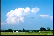
05-20-2001 - E OK struggle!
This image was taken around 23z from just east of Springer,
OK, looking NE at the nearest cell 'up the line', This
multi-cell was quite attractive to watch through its various
and repeated pulses (it never took on any clearly evident
supercellular characteristics). I also enjoyed watching
the lone Longhorn (very small in this image) in the field
between me and the cell - this was a very nice little respite
after the long drive to the Southern Plains - a nice quiet
appreciation of the scene at hand (and a contrast to the
difficult chase that would soon begin)!
Sunday began in Wichita Falls. Had some time to visit and review
data with Dr. Arnold (formerly of MSU) and the students of the
Ball State University Chase Team. Left SPS and headed E to
Gainesville, Denton, and then to sit in Marietta, OK. Chatted
with chaser Ron Granville, and later a Marietta, OK police
officer (who saw the highly visible Springer tornado three weeks
earlier - to the day). Watched the linear SW-NE cu development to
my NW. Moved up to a high vantage point just east of Springer and
watched pulse storm move (shown above) to NW until ~23Z hoping for
later development over me.
At ~2315z, towers started to go up just west and north of me, but
the ones 10 miles N quickly became dominant and took off rapidly ENE
(at maybe 30 kts.). Erred and took 53 E and 177 N (should have
taken I-35 N!). I was quickly trapped in a detour just S of
Sulphur that forced me through the Chickesaw Nat'l Rec. Area at
25 mph on a very windy ascent/decent with no opportunity to turn
off and cars in front and behind. While I am ascending the
mountain I heard a radar indicated TOR warning for the cell just
to my NW at Roff. After that unpleasant experience, I traversed
E in the worst territory I have ever chased in, and the bad dirt
roads made the catch up/intercept attempt seem impossible.
I did see scud rising up and moments later an impressive, cone
shaped - albeit apparently non-rotating - wall cloud about halfway
to the apparent ground for about one or two seconds before
dropping into a valley. I estimate this feature was N-NE of
Tupelo and I would have to guess the approximate time as between
0015 and 0045z as I was focused on driving and trying to figure
out road options. Next glimpse (about five minutes later)
revealed only a slight lowering. Thanks to the chasers operating
very professionally on 146.52, that gave me the road option to
Tupelo, OK just after I witnessed the cone shaped wall cloud
event.
I later learned that I was speaking to Bill Reid of
Tempest Tours (thanks for the guidance Bill!). I had intended
to pick up a new "Roads of OK" upon arrival, but was literally
attempting to get into chase mode within an hour of crossing
the Red River into Texas. More bad roads meant the day was
soon over (although I would occasionally catch a glimpse
of rock hard convection just to my east). A very tough chase
day that produced very little even though I worked *very*
hard at keeping/catching up.
|